MWF
MWF WF 303 GH Ground Water Detector & Professional Water Locator
MWF WF 303 GH Ground Water Detector & Professional Water Locator
SKU: WF303-GH
- Regular price
- Price: $5,199.99
- Regular price
- List Price: $6,987.00
- Sale price
- Price: $5,199.99
- Unit price
- per

⛟ This item qualifies for Free Shipping/ No Sales Tax
Couldn't load pickup availability
Price Match
Price Match
We work very hard to ensure that we offer the absolute best prices online. If you find another online store that offers a lower price than us within six months of your purchase date please let us know and we will refund your original payment for the difference. We want you to feel confident that you are getting the absolute best price for the product you are ordering. If you find that our own website has a lower price for the same item you have ordered within six months of your purchase date will refund the difference as well. >> Learn More
Have questions?
Have questions?
☎ (888) 283-6272 / Mon-Fri 9am-6pm EST or Contact Us
 PRODUCT DESCRIPTION
Description
The MWF WF 303 GH is an advanced ground water detector and professional water locator designed to help users identify underground water sources, artesian wells, and groundwater pathways with greater efficiency.

Built for farmers, drilling contractors, geological exploration teams, and land developers, the WF 303 GH combines long-range scanning technology with deep groundwater detection capability, making it suitable for large-area underground water exploration projects.
HIGHLIGHTS:
Professional Ground Water Detector: Designed for locating underground water sources and artesian wells.
Long-Range Water Locator Technology: Supports large-area groundwater scanning and directional exploration.
Deep Detection Capability: Designed for deep groundwater exploration projects.
Portable Field Operation: Suitable for farms, drilling sites, deserts, and remote land exploration.
Helps Reduce Random Drilling: Improves efficiency by identifying potential groundwater zones before excavation.
Search systems
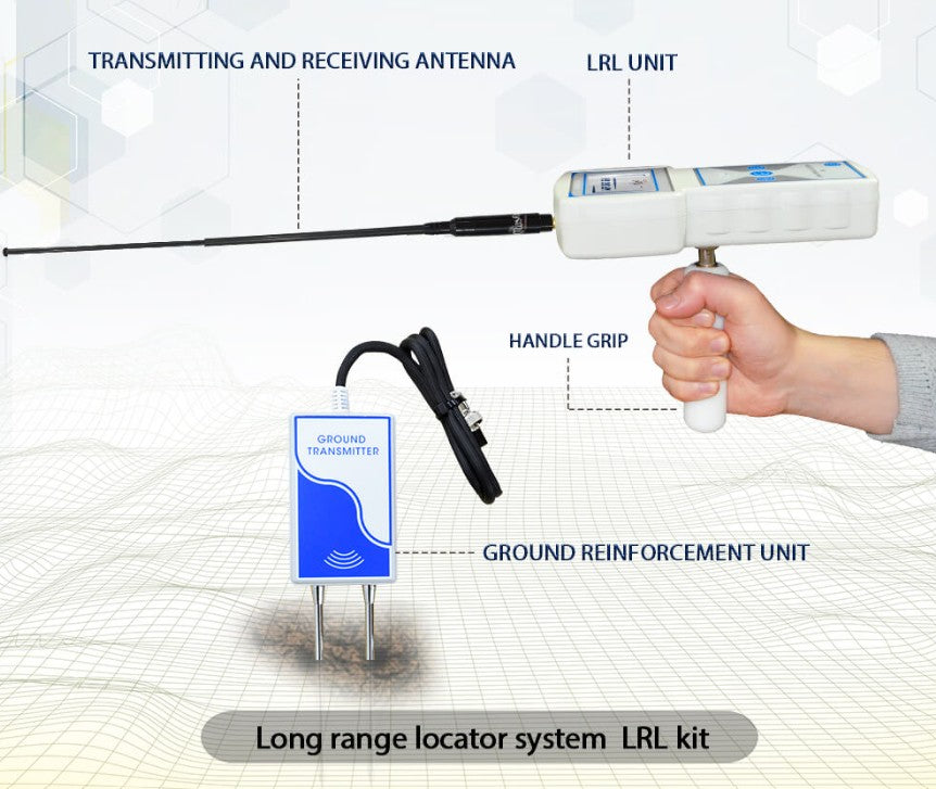
Handheld LRL system:

The advanced and all-new long-range search system with high sensitivity and advanced features, Automated tracking system for accurate tracking of the water point path, audio results, and digital indicators on the screen, determines the point of drilling for water with precision, with full control of search properties and criteria, the depth of search up to 1000 meters, and covers a forward search distance of 2 km with accurate control of search coordinates.
- The user can work on this system through a separate unit, take the search commands and settings by wireless from the main unit or even work on them separately and complete the settings directly from the unit, this system allows the user to track the water direction accurately to determine the drilling point of water.
- Integrated data provided by this system, audio data, smart water location tracking system, track correction feature to track the water location to avoid drilling errors.
- The user can set the search criteria in advance according to the search requirements:
– The user can choose the type of water to be detected in advance: Natural freshwater – Mineral water – Salty water – and all types of water.
Geophysical Search System:

Geophysical System with (VES) technology, which has unprecedented features for automatic detection of water quality and density, determination of drilling point, depth measurement automatically, and determination of soil type as well.
- Advanced algorithms and software to detect and analyze the ground to detect groundwater and to determine its locations and proportions.
- This system scans the entire research area at breakneck speed and provides a detailed report about groundwater the presence points and values.
- The depths are up to 1000 m, with automatic measurement of the level of water depth.
- Provided with 4 Cord reel cables with 4 electro-rods (Probes), covering an area of 1250 square meters.
- This system provides the user with a complete report after completing the scanning, according to the following:
Water type: The water type is automatically detected if it is fresh water, salty water, or mineral water.
Water depth: The depth of the water is automatically detected and shows the level of water depth, for example between 420 meters and up to 520 meters.
Water density: This result shows the density and quantity of water in percentages that inform the user about the abundance of water detected and the extent of continuity.
Highest value: This result shows the highest value of groundwater flow between research electrodes.
Cavities: This result shows whether there are cavities in the drilling area or not.
TECHNICAL SPECIFICATIONS
| Search system: |
1. Advanced Handheld LRL system, acoustic & Guideline LDS
2. Automatic Geophysical Search System (VES) |
| Search principle: |
1. Digital Frequency Signal Processing (DFSP) / To Receiving Electrostatic Fields of the water.
2. Automatic processing to measure & analyze the levels of electrical resistance of the ground and polar groupings (IP) VES technology. |
| Operating processor: | MICROCONTROLLER & ARM 7 |
| Operating Search Frequency: |
1. From 9 kHz to 11 kHz for LRL
2. Automatic measurement of electrical resistance |
| Power: | Main unit: 3 cells 3.7 V, 3000 mAh, LRL unit: 2 cells 3.7 V 2000 mA. |
| Power consumption: | Main unit: Maximum of consumption 400 mA / LRL unit: 200 mA |
| Battery life: | 6 work hours |
| Charger: | 13 volt 3 amp / Charging Time 3 hours |
| Display Type: | Colored 4.3” For main Unit And 3.2” For Attached Unit Screen, 65536 Color, 48Mhz, CDMA GPU |
| Specialized in detects: | Groundwater |
| Targets Discrimination: | Yes |
| Target Selection System: | freshwater – mineral water – salty water – all types of water optional with LRL System, and automatic with the geophysical system. |
| Depth Search: | 1000 m |
| Distance Search: | 2 km for LRL system / 1500 square meters for the geophysical system |
| Results feedback: |
1. LRL, Through Guideline toward target location accompanied by sound + graphical and vibration alerts.
2. Geophysics, automatic results about water type: type / value / density / depth. |
| Wireless: | yes |
| Automatic smart guidance system: | Yes, by a graphical interface to locate the path and direction of the target, and Acoustic commands |
| Sound Alerts: | Yes |
| Vibration alert: | Yes |
| Operating temperature: | From -15° C to 60° C |
| Storage temperature: | From -15° C to 40° C |
| Humidity: | It can be stored and work in the degree rate of air humidity of level 90%. |
| Weight: | 9.25 kg with bag – main unit 1.200 kg – LRL unit 1 kg installed |
| Dimensions: | 26.5x20x5.6 cm, Main unit |
| Bag dimensions: | 50X41X28cm, Full package |
User manual