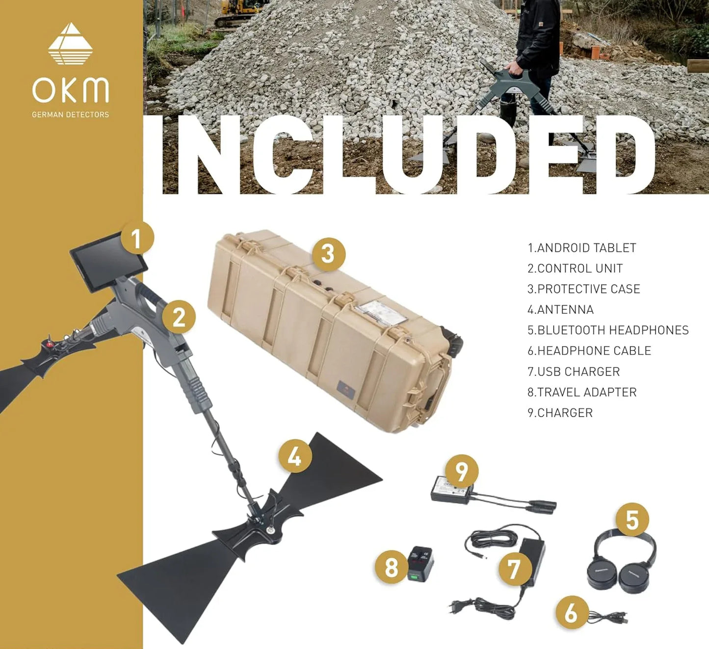
OKM Gepard GPR 3D: Advanced GPR Scanning
High-Performance OKM Gepard Ground Penetrating Radar for Professionals in Detection, Surveying, and Research. Free Worldwide Shipping! Meet Us In Person Or Book a Live Demo Session for The OKM Gepard GPR 3D.
Promotion ends:

Discover the Power of the OKM Gepard GPR 3D
⭐⭐⭐⭐⭐
The OKM Gepard GPR is a compact, flexible, and high-performance ground penetrating radar system that reaches depths of up to 40 m/ 131 ft . Used by archaeologists, engineers, and military professionals across the globe, it offers real-time data, wireless integration, and robust mobility for field deployment.
Key Features of the OKM Gepard GPR 3D
-
Flexible & powerful:
Ground Penetrating Radar using an omnidirectional unshielded transmission system to reach maximum depths.
-
Detection depth:
With this technology customers found objects down to40 m (132 ft) deep.
-
Operating modes:
Ground Scan, Live Stream
-
Detectable objects:
Underground objects like pipelines, cavities, cables, conduits, tunnels, bunkers and foundations.

How the OKM Gepard GPR 3D Detects Underground Structures
The OKM Gepard GPR 3D uses advanced ground-penetrating radar technology to scan deep below the surface and create a detailed 3D visualization of hidden structures. Unlike traditional metal detectors, it can detect not only metals but also voids, tunnels, foundations, and buried objects made of various materials.
This professional system transmits radar signals into the ground, which then bounce back when they hit different layers or anomalies. The built-in software analyzes these reflections and transforms the data into clear 3D images, helping users accurately locate and identify underground targets.
Whether for archaeological exploration, construction surveys, or treasure hunting, the OKM Gepard GPR 3D delivers reliable depth penetration and precise imaging even in challenging soil conditions.

Applications of the OKM Gepard GPR 3D in Archaeology, Construction, and Treasure Hunting
The OKM Gepard GPR 3D Ground Penetrating Radar excels across diverse fields, offering deep subsurface insight up to 40 meters (132 ft). Trusted by professionals, its key use cases include:
- Archaeology — Uncover hidden structures like graves, burial chambers, and ancient walls without excavation.
- Construction & Geotechnical Engineering — Safely map underground utilities, pipelines, foundations, and voids before starting new builds—reducing risk and surprise.
- Treasure Hunting — Locate deep tunnels, bunkers, buried treasure chests, and other valuable anomalies with precision.
Equipped with dual operating modes (Ground Scan and Live Stream), intuitive Android app integration, and superior 2D/3D visualization, the Gepard GPR 3D empowers users to detect underground targets accurately and confidently.
OKM Gepard GPR Scan Analysis in Visualizer 3D Studio
-

As soon as you open a GPR measurement, the Main Toolbar will include a further button. Here you can switch between the 2D and 3D render view.
-

Improve the scan image e.g. by selecting one of the newly added OKM GPR Soil Types (Right Sidebar) and configuring the Visualization (Right Sidebar), e.g. select Smoothing.
-

In the Visualization menu (Right Sidebar), you can change the Threshold to regulate the number of hidden/visible scan values and corresponding colors for the Volumetric render view. This will help you focus on the most significant targets in your scan image.


Why Choose the OKM Gepard GPR from Metal Detectors Pro
When investing in advanced ground penetrating radar, value and expertise matter. At Metal Detectors Pro, we not only provide the OKM Gepard GPR 3D but also guide you with transparent information on the OKM Gepard GPR price, ensuring you get the best deal. Customers choose us because we offer:
- Expert Support – Our team provides guidance to help you select and use the right OKM detector. We also offer free live demo session (Online/In person).
- Competitive Pricing – We offer best price guaranteed / price match + Extra bonus.
- Trusted Reliability – Authorized dealer. Durable, field-tested devices backed by manufacturer warranties.


OKM Gepard GPR 3D German Ground Penetrating Radar