Geoground
Detector de aguas subterráneas GeoGround Water Line
Detector de aguas subterráneas GeoGround Water Line
Código SKU: Water-Line
- Precio habitual
- Price: $2,750.00
- Precio habitual
- Precio de lista: $3,648.00
- Precio de oferta
- Price: $2,750.00
- Precio unitario
- por

⛟ Este artículo califica para envío gratuito / sin impuestos sobre las ventas
En existencias
No se pudo cargar la disponibilidad de retiro
Igualación de precios
Igualación de precios
Nos esforzamos al máximo para ofrecer los mejores precios online. Si encuentra otra tienda online con un precio inferior al nuestro en los seis meses posteriores a su compra, infórmenos y le reembolsaremos la diferencia. Queremos que tenga la seguridad de obtener el mejor precio por el producto que solicita. Si encuentra que nuestra tienda online tiene un precio inferior para el mismo artículo que solicitó en los seis meses posteriores a su compra, también le reembolsaremos la diferencia. >> Más información
¿Tienes preguntas?
¿Tienes preguntas?
☎ (888) 283-6272 / lunes a viernes de 9 a. m. a 6 p. m. EST o contáctenos
 PRODUCT DESCRIPTION
Descripción
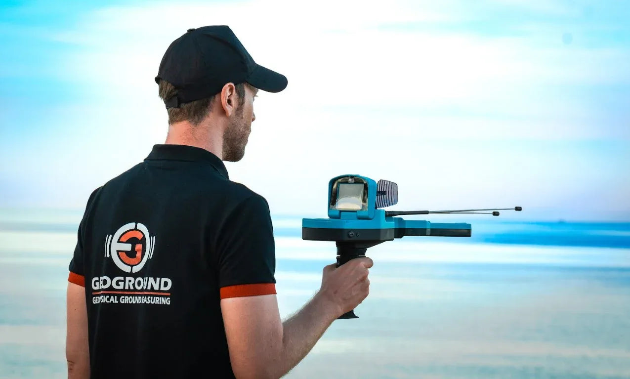
La línea GeoGround Water ofrece detección de aguas subterráneas de nivel profesional con un impresionante alcance operativo de 3000 m y una profundidad de penetración de 1200 m . Este localizador avanzado destaca en el desarrollo de pozos, aplicaciones agrícolas, exploración geológica y mapeo de aguas subterráneas. Diseñado para especialistas que exigen análisis fiables del subsuelo e identificación precisa de fuentes de agua.
REFLEJOS:
Tecnología de localización de largo alcance: Water Line utiliza tecnología avanzada de localización de largo alcance (LRL) que combina antenas, una antena amplificadora de señal y un sensor inteligente, lo que permite la detección de fuentes de agua subterránea desde grandes distancias.
Gran alcance y capacidad de profundidad: el dispositivo admite un rango de escaneo de hasta 3000 metros y puede detectar fuentes de agua a una profundidad de hasta 1200 metros bajo tierra , lo que brinda acceso a acuíferos profundos o depósitos de agua que muchos buscadores de agua estándar no pueden alcanzar.
Admite fuentes de agua dulce, normal y salada: Water Line es capaz de localizar diferentes tipos de agua: dulce, normal (agua subterránea) e incluso salada/salobre, lo que lo hace versátil para pozos, agricultura o zonas costeras/ricas en arsénico.
Configuraciones de búsqueda personalizables: los usuarios pueden configurar y ajustar tanto la distancia de búsqueda como la profundidad de escaneo según el tipo de terreno y sus requisitos, lo que ayuda a identificar con precisión posibles depósitos de agua y evitar excavaciones innecesarias.
Interfaz fácil de usar y soporte multilingüe: el software de Water Line cuenta con una GUI clara e intuitiva, con soporte para múltiples idiomas, lo que lo hace accesible para usuarios de todo el mundo independientemente del idioma o la experiencia técnica.
Incluye:
- Unidad electrónica principal
- Sensor inteligente
- Antena amplificadora de señal
- Unidad de manija inalámbrica
- Antenas de RF
- Cargador de dispositivo
- Manual de usuario
- Tarjeta de garantía
* Garantía de 2 años.
FUNCIONES Y SISTEMAS DE BÚSQUEDA
Tecnología de localización de largo alcance para la detección de aguas subterráneas
Water Line, un innovador dispositivo detector de aguas subterráneas, aprovecha el poder de la tecnología de localización de largo alcance (LRL) para localizar recursos hídricos subterráneos de forma remota desde largas distancias.
Los usuarios pueden personalizar el proceso de búsqueda para obtener resultados precisos, ya que pueden configurar con precisión el rango de escaneo y el rango de profundidad, lo que les permite apuntar a áreas específicas con la máxima precisión.
Este notable rendimiento es posible gracias a una combinación de antenas, un amplificador de señal y un sensor inteligente de última generación, lo que garantiza una precisión y eficiencia de detección incomparables.
Con Water Line, descubrir recursos ocultos de aguas subterráneas nunca ha sido más fácil ni más eficiente.
Herramientas de detección
El dispositivo detector de aguas subterráneas Water Line utiliza una combinación sofisticada de antenas, una antena amplificadora de señal y un sensor inteligente para detectar y localizar recursos de aguas subterráneas de manera eficaz.
Juntos, estos componentes trabajan armoniosamente para formar un sistema de detección integral.
Las antenas capturan señales electromagnéticas, el amplificador de señal mejora la recepción de señales y el sensor inteligente recopila y analiza los datos de escaneo.
Al combinar la información recopilada de estos componentes, Water Line puede determinar con precisión la ubicación de las fuentes de agua subterránea, lo que permite a los usuarios tomar decisiones informadas con respecto a la exploración y gestión del agua.
Antenas de búsqueda
Las antenas actúan como receptores primarios de señales electromagnéticas resultantes de los campos electromagnéticos generados debido a la presencia de recursos y depósitos de agua subterránea y que se propagan a través de diferentes capas de suelo y formaciones rocosas.
Como estas ondas encuentran diferencias en la conductividad eléctrica y permitividad con respecto al suelo, están sujetas a modificaciones en su frecuencia, amplitud y fase y el dispositivo recibe las señales resultantes y las convierte en señales digitales para su análisis dentro del dispositivo.
Antena amplificadora de señal
La antena amplificadora de señal juega un papel vital en la mejora de la recepción de las señales mencionadas en el párrafo anterior.
Funciona para amplificar las ondas electromagnéticas más débiles emitidas con el fin de garantizar una mayor precisión en la determinación de la ubicación de la fuente de agua.
Sensor inteligente
El sensor inteligente es un componente altamente avanzado que integra tecnologías de detección avanzadas a través de sus sensores electrónicos incorporados y funciona en conjunto con antenas y plato amplificador de señal para recopilar e interpretar datos de señales recibidas debajo de la superficie para guiar al usuario a la posición precisa de un posible recurso hídrico.
Una característica importante del sensor inteligente es que las pequeñas luces LED ubicadas en la parte superior se iluminan en color azul cuando detecta la presencia de una fuente de agua subterránea cercana.
El sensor inteligente es capaz de detectar variaciones sutiles en los campos electromagnéticos y las propiedades eléctricas del suelo, proporcionando información valiosa sobre la presencia y las características de los recursos de agua subterránea.
Opciones de búsqueda personalizadas
El dispositivo proporciona una experiencia de usuario muy simplificada y fácil para buscar fuentes de agua subterránea.
Sin embargo, proporciona un conjunto de opciones que personalizan el proceso de búsqueda para adaptarse a las necesidades del usuario, las capacidades de perforación y la naturaleza del terreno.
Las opciones que el usuario puede ajustar y personalizar incluyen las siguientes
Tipo de agua
El dispositivo Water Line permite al usuario seleccionar un tipo de agua, lo que le permite especificar el tipo específico de agua que está buscando dentro del área objetivo.
El dispositivo puede detectar tres tipos principales de agua:
1 – Agua Normal: se refiere al agua subterránea estándar.
2 – Agua dulce: que denota fuentes de agua limpia y no salina
3 – Agua Salada: indica la presencia de agua salina o salobre.
Al elegir el tipo de agua deseado, los usuarios pueden adaptar su búsqueda para centrarse en una categoría particular de recursos hídricos.
Distancia
Esta función permite a los usuarios indicar el rango de búsqueda dentro del área objetivo.
Al utilizar esta opción, el usuario puede especificar la distancia que debe cubrir el dispositivo Water Line mientras realiza su búsqueda.
Cabe destacar que el dispositivo tiene la capacidad de buscar a distancias de hasta 3000 metros, destacando su impresionante amplio rango de escaneo.
Con una cobertura tan amplia, los usuarios pueden explorar territorios extensos cuando buscan posibles fuentes de agua, lo que hace que el dispositivo sea altamente eficiente y efectivo en sus capacidades de detección de aguas subterráneas.
El usuario puede ajustar el valor de la distancia con precisión dentro del rango de 0 a 3000 metros.
Profundidad
Esta función indica la profundidad máxima del rango de escaneo dentro o debajo del área objetivo.
El dispositivo Water Line destaca por su capacidad para detectar fuentes de agua a una profundidad de hasta 1.200 metros bajo tierra, lo que le permite descubrir una mayoría significativa de objetivos dentro del área de búsqueda.
Además, las excepcionales capacidades del dispositivo permiten acceder a depósitos de agua previamente inaccesibles a profundidades impresionantes. Con esta capacidad, Water Line permite a los usuarios acceder a fuentes de agua previamente inexploradas, ampliando así las posibilidades de descubrir valiosos recursos hídricos subterráneos.
El usuario también puede establecer el valor de profundidad con precisión dentro del rango de 0 a 1200 metros.
Escanear
Una vez que el usuario ha seleccionado la configuración deseada, tiene la opción de iniciar la búsqueda, comenzando el proceso de escaneo.
En esta etapa, puede revisar todas las configuraciones previamente especificadas. Es fundamental confirmar que la configuración elegida se ajuste a sus requisitos de búsqueda.
Para iniciar el proceso de escaneo, simplemente presione el botón OK en el teclado.
Al completar la configuración inicial, aparecerá una ventana de advertencia que nos solicitará que presionemos el botón Inicio o el botón Aceptar del teclado para iniciar la calibración e ingresar a la pantalla de búsqueda que guía al usuario a través de indicadores visuales hasta la ubicación objetivo.
Programa multilingüe fácil de usar
El programa de software del dispositivo Water Line presenta una atractiva interfaz gráfica de usuario (GUI) que presenta un diseño moderno y mantiene un esquema de colores consistente.
La interfaz utiliza un sistema de menú único con pestañas diferenciadas para las configuraciones, acompañadas de íconos expresivos que representan visualmente cada opción y configuración.
Este diseño cuidadoso mejora la experiencia del usuario al facilitar la selección de varias opciones de una manera fluida y visualmente intuitiva.
Además, la interfaz del dispositivo ofrece opciones de personalización para diversos ajustes generales. Estos ajustes incluyen la fecha y hora para la sincronización, ajustes de pantalla como el ajuste del brillo, ajustes de sonido como el volumen de las teclas y el control del volumen del sonido de escaneo, la selección del idioma del programa y la visualización de información general como el número de serie y otros detalles relevantes.
Este conjunto integral de opciones personalizables permite a los usuarios adaptar el dispositivo Water Line a sus preferencias y requisitos específicos, garantizando una experiencia personalizada y fácil de usar.
Idiomas
Los usuarios ahora tienen la opción de seleccionar su idioma preferido de un conjunto cuidadosamente seleccionado de idiomas, que incluye:
Inglés – Alemán – Español – Francés – Ruso – Italiano – Árabe – Persa.
Al ofrecer esta variada selección de idiomas, Geoground garantiza que los prospectores de diversos orígenes lingüísticos puedan acceder y utilizar fácilmente el dispositivo Water Line, lo que promueve la inclusión y la facilidad de uso a escala global.
Descargas