


GER Detect
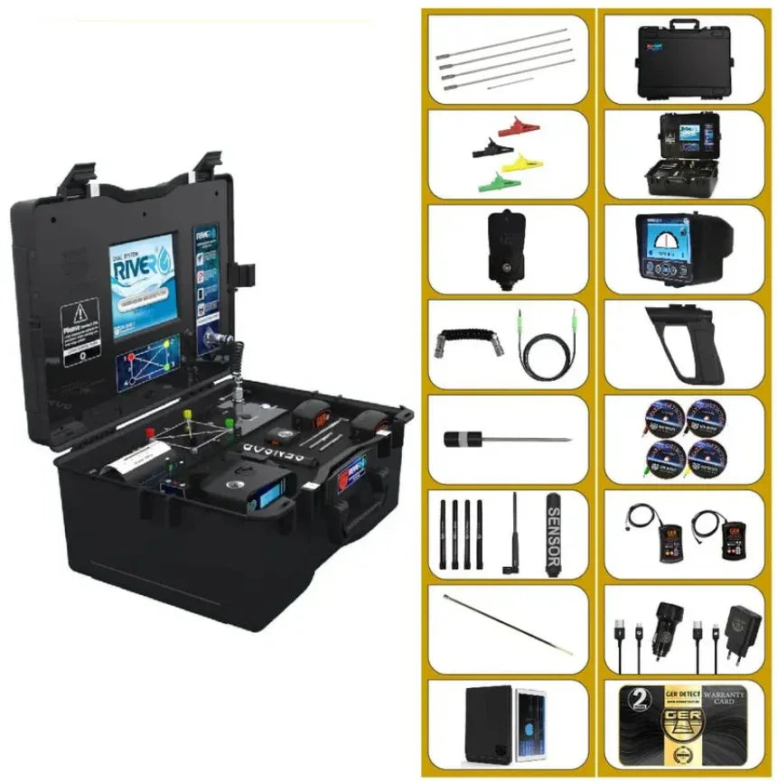
GER Detect RIVER G 3 Systems Groundwater Locator
GER Detect RIVER G 3 Systems Groundwater Locator
SKU: River-G-3
- Regular price
- Price: $6,999.98
- Regular price
- List Price: $7,689.00
- Sale price
- Price: $6,999.98
- Unit price
- per

⛟ This item qualifies for Free Shipping/ No Sales Tax
In stock
Couldn't load pickup availability
Price Match
Price Match
We work very hard to ensure that we offer the absolute best prices online. If you find another online store that offers a lower price than us within six months of your purchase date please let us know and we will refund your original payment for the difference. We want you to feel confident that you are getting the absolute best price for the product you are ordering. If you find that our own website has a lower price for the same item you have ordered within six months of your purchase date will refund the difference as well. >> Learn More
Have questions?
Have questions?
☎ (888) 283-6272 / Mon-Fri 9am-6pm EST or Contact Us
 PRODUCT DESCRIPTION
Description
The GER Detect RIVER G 3 Systems Detector , an advanced multi-system device for locating underground water, artesian wells, and springs with 3D imaging, geophysical search, and long-range sensing up to 1500 m depth and 3000 m range. Precision detection worldwide.
HIGHLIGHTS:
Advanced 3-System Detection Technology: Combines 3D ground imaging, geophysical analysis, and long-range sensing in one powerful device for precise underground water detection.
Deep Water Detection Capability: Designed to locate underground water sources, artesian wells, and springs at depths of up to 1500 meters, ideal for professional and industrial use.
Extended Long-Range Search Coverage: Features long-range detection with a horizontal reach of up to 3000 meters, allowing wide-area exploration before excavation.
High-Accuracy 3D Visualization Software: Provides detailed 3D graphical imaging to analyze depth, location, and volume of water targets with greater confidence and reduced drilling risk.
Built for Professionals & Harsh Environments: Engineered for reliability in desert, rocky, and mineralized terrain, making it suitable for geological surveys, agriculture, and water exploration projects worldwide.
Includes:

* 2-Year Warranty.

3D Imaging Search System – Geophysical Search System – Long-Range Sensing System The device offers highly precise capabilities to determine the type of water — whether fresh, salty, or very salty, at depths of up to 1,500 meters below the ground and a forward detection range of 3,000 square meters. At last, the exhaustion and random searching are over. We now place in the hands of explorers and water detection enthusiasts a modern, one-of-a-kind technology for discovering groundwater, artesian wells, and underground springs.

Operates with three different search systems

Multilingual
A practical device that supports six main languages: Arabic, English, German, French, Spanish, and Portuguese. It is designed to provide ease of use and multilingual flexibility, making it suitable for users all around the world.
The RIVER - G 3 SYSTEMS device is designed to operate efficiently in all countries and regions
The true journey of exploration does not require traveling to new lands, but rather seeing with new eyes. We wish you success in all your exploration journeys.
Downloads


GER Detect RIVER G Groundwater Locator | Frequently Asked Questions
What is the GER Detect RIVER G 3 Systems Groundwater Locator?
The GER Detect RIVER G 3 Systems Groundwater Locator is a professional multi-system device designed for underground water exploration. According to GER Detect, the RIVER G is intended to help locate groundwater, artesian wells, borewells, and underground springs. It combines three different search methods in one system: 3D Imaging, Geophysical Search, and Long-Range Sensing.
What are the three search systems in the GER Detect RIVER G?
The RIVER G incorporates three search systems:
- 3D Imaging Search System – Designed to provide visualized information about underground water layers and related subsurface data.
- Geophysical Search System – Uses measurements taken through ground probes to investigate potential underground water.
- Long-Range Sensing Search System – Intended for preliminary exploration of larger areas to help identify potential water locations.
The combination allows an operator to approach groundwater exploration using several methods rather than relying on a single search system.
How deep can the RIVER G detect underground water?
GER Detect specifies a maximum search depth of up to 1,500 meters for the RIVER G 3 Systems Detector. The manufacturer also states that the system can determine the depth of detected underground water.
Actual field results should not be assumed to be identical at every location. Subsurface geology, soil characteristics, water-bearing formations, measurement conditions, setup, and operator technique can all be relevant when conducting groundwater exploration.
What is the search range of the RIVER G groundwater detector?
According to GER Detect, the RIVER G's long-range system offers a forward search range of up to 3,000 meters, with selectable range settings including 500, 1,000, 1,500, 2,000, 2,500, and 3,000 meters.
The long-range function is intended for exploring larger areas before narrowing the investigation to a more specific location.
Can the RIVER G determine whether underground water is fresh or salty?
GER Detect states that the RIVER G is designed to provide information about water type, including classifications such as fresh, salty, and very salty water. The manufacturer describes its geophysical and 3D imaging systems as providing information related to water type, depth, density, and salinity.
As with any groundwater exploration equipment, electronic indications should be considered part of the site investigation rather than a substitute for drilling, sampling, or laboratory water-quality testing when definitive confirmation is required.
Can the RIVER G help determine where to drill a water well?
Yes. One of the RIVER G's intended applications is helping the operator identify a promising location for further groundwater investigation. GER Detect states that its system provides an indication for the preferred drilling location and uses its measurements to provide information about underground water.
For an actual well project, detector results can be considered alongside local hydrogeology, geological information, existing well records, professional surveys, and ultimately drilling.
Can the RIVER G locate artesian wells and underground springs?
The manufacturer specifically designed the RIVER G for searching for groundwater, artesian wells, borewells, and underground springs. This makes it different from a conventional metal detector, which is designed primarily to detect metallic objects rather than investigate underground water.
How does the geophysical system of the RIVER G work?
The RIVER G user manual describes the system as using resistance measurements and frequency detection. It measures resistance between the surface and subsurface and analyzes measured values against background values before displaying results to the operator.
The geophysical portion uses probes and cables placed in the ground as part of the measurement process. The current technical specifications list 20-meter cables and geophysical probes for the system.
What does the RIVER G 3D Imaging System show?
According to GER Detect, the 3D Imaging Search System is designed to display information associated with potential underground water layers in a three-dimensional visualization. The manufacturer states that its analysis can display information related to water depth, water type, salinity, water density, and surrounding rock density.
It is important to understand that 3D imaging is not an underground photograph or X-ray. It is a visualization generated from collected measurement data and therefore requires proper operation and interpretation.
Is the GER Detect RIVER G suitable for large properties?
The RIVER G is specifically positioned as a professional groundwater locator for larger-area exploration. Its combination of a long-range search system and more localized geophysical and imaging methods allows different stages of a site to be investigated with the same platform.
This can make it relevant to applications involving farmland, agricultural projects, large private properties, groundwater exploration projects, and professional water surveys.
Who is the RIVER G designed for?
The RIVER G may be suitable for users who need a professional underground water detector for more involved groundwater exploration, including:
- Farmers and agricultural landowners
- Agricultural development projects
- Groundwater exploration companies
- Well and borehole projects
- Researchers and field explorers
- Land investors
- Professional water-search operations
GER Detect itself identifies farmers, agricultural land investors, researchers, explorers, and water-exploration companies among the intended users of the system.
How long does the RIVER G battery last?
The manufacturer's technical specifications list approximately 8–12 hours of operating time for the geophysical system's 54 Wh rechargeable lithium-ion battery. The long-range system is listed with approximately 10 hours of operating time.
Is the RIVER G waterproof?
No. GER Detect's technical specifications describe the detector as weatherproof only, not waterproof. The equipment therefore should not be submerged or treated as waterproof during field operation.
Does the RIVER G guarantee that drilling will produce water?
No groundwater locator should be interpreted as a guarantee that drilling at a particular location will produce a commercially useful water well.
The RIVER G is designed to provide information that can help identify and evaluate potential underground water locations. Final confirmation ultimately depends on the actual subsurface conditions encountered through drilling and, where appropriate, professional hydrogeological investigation.
For a high-cost drilling project, using multiple sources of evidence is much more prudent than relying on a single electronic indication.
Have a question about product?
Phone number: (888) 283-6272
WhatsApp: +1 919-650-0680
(Working time: 9am-5pm EST, Mondays to Fridays)


